


bonno

marcmoitz
User
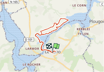

Length
8.4 km

Max alt
28 m

Uphill gradient
105 m
Km-Effort
9.8 km

Min alt
0 m

Downhill gradient
103 m
Boucle
Yes
Creation date :
2025-03-28 08:50:03.961
Updated on :
2025-03-28 12:46:37.917
3h55
Difficulty : Medium

FREE GPS app for hiking
 SityTrail
IGN / Geographical institutes
SityTrail Plus
The world is yours!
About
Trail Walking of 8.4 km to be discovered at Brittany, Morbihan, Le Bono. This trail is proposed by marcmoitz.
Positioning
Country:
France
Region :
Brittany
Department/Province :
Morbihan
Municipality :
Le Bono
Location:
Unknown
Start:(Dec)
Start:(UTM)
503903 ; 5276293 (30T) N.
Comments